8/9/05 - day 5 | ||
 |
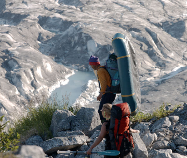
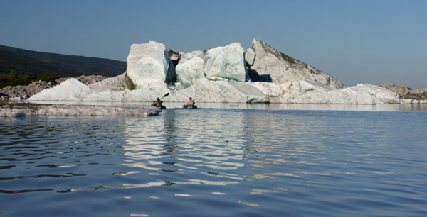
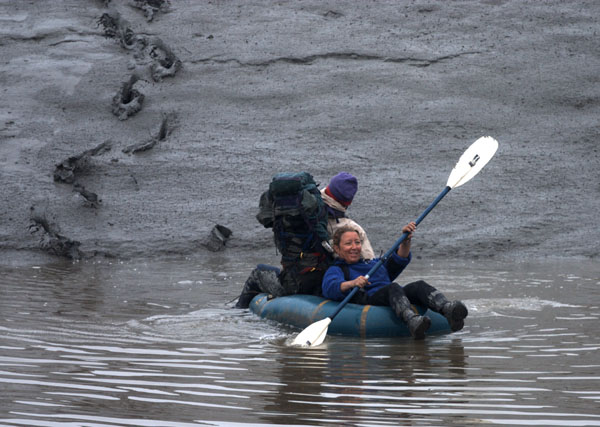
We've pretty much tried everything at this point, but true to its name, Blockade has finally stopped us. We followed our high route to a gully, and scrambled back down and out onto the glacier. This time the glacier worked out better for us. We crossed out to the center and made it almost all the way to the end, where we cut back up onto land. Then we hit a waterfall in the gorge, which stumped us again. But we have many tricks. We carefully packed up the crampons, pulled out the rafts, and wove our way through the icebergs in the packrafts. |
|
 |
 |
 |
|
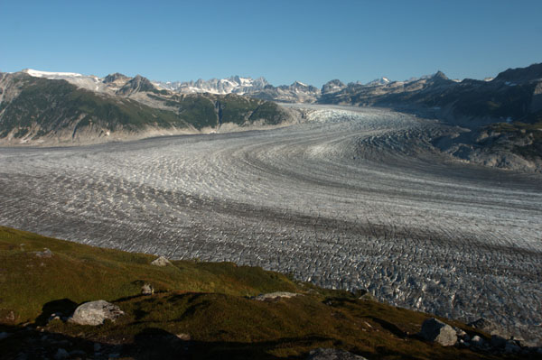
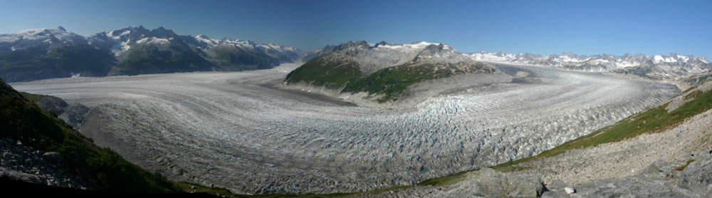
And then we were up and out, climbing up over Blockade Lake. I only know it's a lake from the name on the map. It's basically a great floating field of icebergs rimmed by steep talus on one edge, and cliffs on the the other. It's over six miles long, and there's not even space to get an Alpacka raft through. It's a lake with basically no water. From most angles, there's none at all. And from straight above the lake, all that can be seen is a narrow and discontinuous path along the edge. Our hopes of paddling the lake were shot. There was no shore to speak of. |
 |
|
 |
 |
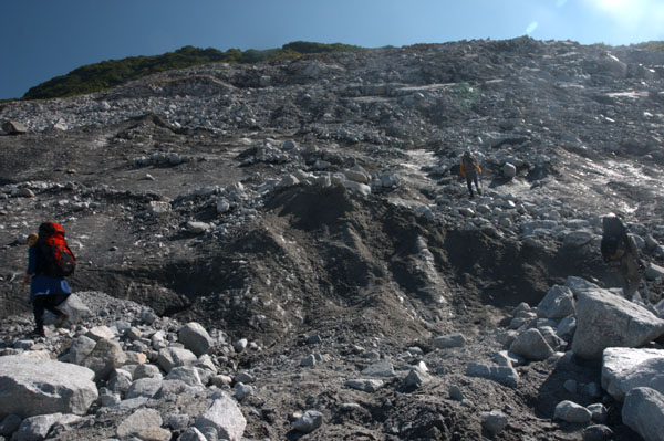
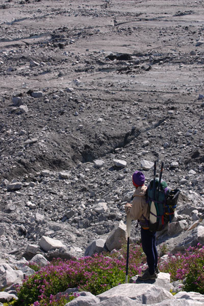
So we made yet another scramble over the oversteepened ice and boulders, up to a heathery meadow. We skirted the lake along a small ledge left by the last ice age, climbing up and down and through small gullies. Sue almost got crushed by a boulder in one of those gullies. It slid down on her as she knocked some lower rocks down, and she was just able to hold it up long enough for Gordy to get back and pull it off of her. And from there, all we could get to was a real gorge. A steep wide valley with a rushing torrent of water, topped by a glacier, and separated from us by a sheer cliff. That's where we sat down to do some serious rethinking. We probably could have cut over that gorge, but getting all the way around the lake on the high route seemed extremely doubtful. We'd have to use the ice-choked lake. We decided to retreat and camp, where Hig and I would scout the lake for one last chance, hoping vainly to push the icebergs out of our path. |
|
So we tossed our stuff at camp and picked our way back down to the edge of the so-called lake, tossing our rafts into the narrow margin of waters. We paddled around, pushed a few icebergs out of the way, and scrambed over the rocks at the edge of the lake to get around the ones we couldn't push. We made it about 50 feet before giving in. It was too choked up. If the lake was half a mile long, I might have tried it. But six miles? No. | >
 |
|
8/10/05 - day 6 | ||
 |
||
|
We thought we had the perfect retreat planned. Back down to the glacier, paddle the pond around the waterfall, crampon over to a smooth tundra nose on the far side of the glaicer, walk up and over and down the valley on the other side - back to the McArthur River. It almost worked. |
||
 |
 |
 |
|
The little pond was frozen over with skim ice from the night's freeze, so the Alpackas had to act as ice breakers. Hig paddled out ahead, leaving a shining curved path which wove through the icebergs on the pond. Pushing the raft through the tight spots between bergs is slow, and I'm glad we weren't trying to do that for 6 miles down the lake. |
 |
|
 |
 |
 |
 |
Then I struggled into my antiquated and too-large crampons yet again, advancing to what was probably the seventh different strapping system for them, and ensuring that everyone in the group had tried at least once to figure a better way to strap them on. One minute later, I noticed one was loose, and got Hig to adjust it for me. 30 seconds after that, I broke right through the steel. Luckily, I mananged to make it across the ice on a string and duct tape fix, but I'm not sure it'll hold for tomorrow. |
|
|
There was a cold wind on the glacier today, whipping at our faces as we crunched over moungds of ice and hopped small crevasses. I can hop just fine, as long as I remember to never look down. The glacier is beautiful, but travel on it is somewhat monotonous, and I was happy when we found and eaasy way up onto our tundra nose. I'd worried that the exit from the glacier would stop us. A short scramble up a talus gully brought us to the most beautiful tundra ridge you'll ever see. A rolling expanse of heather, dwarf willow and blueberries, carpeting our way up to the peak. Down the other side we feared a bushwhack, but this side was golden. |
 |
 |
 |
 |
 |
|
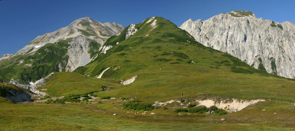
So we tramped up the 1500 foot climb, trudging a bit at the end, stepped up onto the peak, looked over the edge, and gaped. The ridge waas gone. It was a rolling expanse of tundra where we were. It was a rolling expanse of tundra 200 feet away. But in between, there was nothing but a slim and gagged knife edge of crumbly rock. Apparently the bears sometimes go that way, and Hig poked a short ways out aong their trail, but it is steep! And tremendously exposed, with rocks crashing down for horrible distances as his feet dislodged them. None of the rest of us would have walked it even that far, and Hig didn't really like it either. So we've been stopped, again. We're still in Blockade valley, and Blockade valley is still an amazingly beautiful place, which we just can't seem to leave. |
||
 |
 |
 |
8/11/05 - day 7 | ||
 |
||
|
I can't see Blockade Glacier from here. Of course, if I walked 50 feet toward the river, I could see it, but that doesn't matter. We're free of it, finally. Free of an awe-inspiring, beautiful, and utterly frustrating place. We didn't go back across the glacier after all. Last night we climbed all the way back down our tundra nose, and this morning we traversed around to a climb that would take us up to the far side of the pass, beyond the missing chunk of ridge. We were almost certain it was going to work, but after the last few days, none of us was willing to say anything for certain. |
 |
 |
 |
What it looked like we'd get was a bushwhack, and a bushwhack is sure what we got. The climb to the pass worked beautifully, and we followed the burbling clear stream down towards the flat of the valley. Even this late in the year, the gully was packed with snow, and scattered with avalanche rubble. The further we went, the more it was rough. Meadow breaks were fewer and farther between, and we were mostly thrashing through willow, shredding Gordy's polypropylene pants. So Gordy ended up walking along, legs armored in packing tape, swearing at all the bushes. I don't know if alder object to being called ugly names, but they sure didn't give us any breaks. The place where we were worried about cliffs turned out to be ok, so we started bombing our way down and out, looking longingly at the iceberg-strewn lake in the distance. |
|
 |
 |
And that's the last we saw of it for quite a while. The descent took us 3 hours. We thrashed down into thicker and thicker devil's club, until it stabilized at about as thick as it could get. OUr only breaks came from the occasional foray out to wade the edge of the bouldery creek. Otherwise, it was nothing but pure unbroken devil's club and alder. |
|
We were all desperately happy to see the lake, and quickly jumped in with oru rafts until we ran right into a piece of Blockade Glacier. It wasn't quite done sith us. A few ponds and inflated-raft portages later, we hit the river proper, and jumped right into the rapids. The rapids weren't tippy, but they sure were wet. Two minutes in, we all had to dump our boats. Another couple minutes of wet, and we decided it was time to camp. We built a fire in a great little lee of a sandy gully, and tried to dry out what we'll wet again tomorrow. We were moving from 8:15 to about 9:45, and it's late enough now I'm using a flashlight to write by. Hig's lost the map somehow, but it should be all downstream from here. |
 |
 |
8/13/05 - day 8 and 9 | ||
|
I'm sitting here clean and happy on a log in Shirleyville, telling the story of our trip to the folks at the oil camp here. I would have written last night, but I was spending my time tromping the mudflats in the dark, looking for my kit with all my most important possessions inside it. Yesterday we left sight of Blockade Glacier for good. We hopped into the boats, got wet in a few more little rapids, then began the lazy hot float down the McArthur River, swishing past sandy banks, getting our last glimpses of Blockade Glacier around the bends of the river. We had a brief chat with a few beer-drinking fishermen who'd been dropped off at a riverside airstrip, and then the river swept us down into the trees and beyond the glacier. But not before Hig retrieved a souvenir of the trip, stopping to pick up one of the busted rockets we'd noticed on the way up. By this point, I found the desire to bombard Blockade Glacier to be quite understandable. |
 |
|
 |
A warm breeze swept over the river intermittenly, and I kept nodding off for a minute or two at a time, waking up disoriented as my boat spun in the current. The river wasn't that fast, but it wasn't that slow eiher, and it sped up as more water joined from the Chackachatna, and other channels from Blockade Glacier. It widened as we rode along, until Hig's raft was barely visible paddling along the far bank. |
|
|
We stopped for dinner at the edge of the tide flats, adding beach greens and birch boletes to our last meal of chowder and split pea soup. We figured (from knowing when high tide was a week ago), that the tide should be low and rising, perfect for carrying our boats up the inlet to Shirleyville. Or so we thought. |
 |
 |
 |
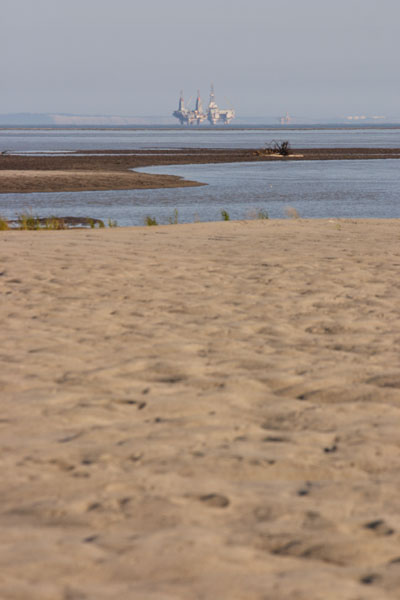
We paddled off towards the oil rigs, hoping the deeper water would bring us a tidal current whipping along the coast. No such luck. We watched a beautiful sunset over the mountains as we tried to get GPS readings on our non-paddling speed (Gordy had a GPS). Unfortunately, all we got was readings fluctuating between 0 and 1.8 (the lower limit of the GPS's measurements), and that was probably just the breeze pushing us. We pointed our boats towards the lights of the Shirleyville tank farms, and paddled into the darkness. The oil rig lights shone to our right, but our landmarks on the shore quickly turned into an indistinguishable wall of blackness. After awhile we felt there wasn't much point to paddling through the night, and we pulled up onto the mudflats. |
|
|
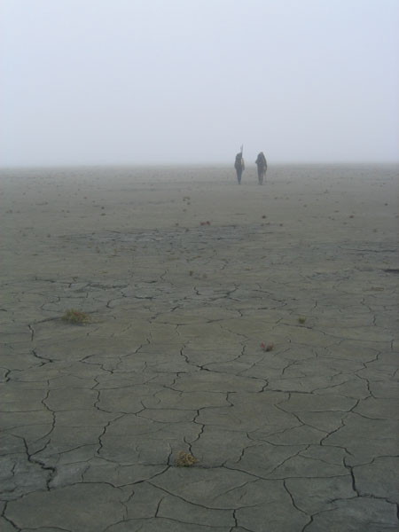
It was midnight, and our shoes sank into the goo as we dragged the rafts over a long, flat, and slippery path to dry ground. We followed a slough just far enough to find a few bits of dry grass, and figured since it was already about high tide, we'd be fine, even only a few feet above (and a quarter mile away from) the water line. As soon as I dropped the pack, I realized something was missing. I didn't have my kit. I didn't have my fanny pack kit with my knife, my emergency gear, my EPIRB, my money, my credit card, my ID, etc... Shit. I knew I'd had it in the boat, but as best as I could figure, it was out on the mudflats in the dark, probably on its way to being washed out by the tide. Back to the beach with Hig's flashlight (mine was in the kit). Sue came along, but I had little hope we'd find anything. My shoes sucked half-off my foot with each step as I paralleled the beach in the wet goop, hoping to cross our tracks. I eventually found them, and tried to follow them out to the water, thinking I'd lost the bag there. No luck. As the mud got wetter and wetter, there were no longer any tracks to be seen. All my feet left were gooey pools indistinguishable from the thousands of natural ones. I was sure the tide had gotten it. Sue caught up with me, and we followed the tracks back inland, looking for mine. Luckily I'm very duck-footed, and my tracks are unmistakeable. As soon as I found them, I found the kit. Sitting on the mud, looking just as if it was placed there on purpose. Full of relief and covered with mud, we hurried back to our slightly drier campsite. This morning we woke up, fruitlessly tried to remove a few extra pounds of mud from our shoes, and and started out across the mudflats in the thick fog. It was the first weather that was anything short of gorgeous, and it dashed our plans to navigate to Shirleyville by sight. So we pulled out the compass. We slipped and slid, crossed one slough in the rafts, made frequent deviations inland for slightly less sloppy walking, and eventually ended up at some oil buildings, and a road into Shirleyville. Here we've gotten about the best reception ever, with hot food, hot showers, hot coffee, and good company. We told Susan (the cook) and Jim (the guy we met on our first time through) all about our trip, and we're waiting on the fog to lift so we can fly back to Anchorage. |
||
 |
 |
 |