6/17/04 - day 9 | ||
 |
We were supposed to wake up early, to be sure to be at the Chikamin river by high tide. So of course we yawned, grumbled, and fell into naps a few times, but we still managed to get on the water by about 8:30, which is early for us. And all this despite the miles of beach between camp and the ocean at low tide. Lately, we can't avoid leaving camp at low tide. And though it's not literally miles to the low tide line, with a 15 foot tide and a gently sloping beach, it can seem like miles. I imagine my arms must be getting stronger with all this paddling, but those boats only seem to get heavier. |
|
|
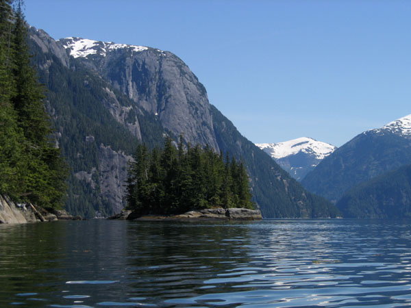
It was hot enough today that I gave up the raincoat entirely to paddle with just the life vest. My arms are still puny and very pale-looking, but I swear they do look stronger than when we started. The 24 miles of paddling today are bound to help. We didn't take our customary break for a hot lunch, since we were trying to reach the Chikamin river by high tide. We paddled back across a sharp line into milky-fresh water, where scum floated on the surface, and horse flies abounded. Horseflies like to follow the kayaks, and are easily fast enough to do so. The seals don't seem to care about salinity or cloudiness, and they spied and splashed as usual. One seal splashed close enough to my kayak that I got sprayed. They're going to tip us over one of these days. We still haven't a clue what the splashing is for. Are they asserting their territorial ownership in the face of our threatening little blue boats? Are they stunning the fish with a noisy slap of the water? Or are they just playing? We paddled way up into the flats of the river mouth, right through fizzing tide-covered grasses. Trails of bubbles plumed up from every tuft of grass. |
||
 |
 |
 |
 |
 |
After the river, there was no place else to stop until our home here, explaining the 24 mile day. Beaches are scarce here, while rocky cliffs are abundant. And beaches that still exist at high tide are rarer yet. High tide today is at 1:30 AM, so we are left praying our judgment of the tide lines is correct. |
|
Today the channel was marked by porpoises of some sort, black-finned and surfacing right near us. They looked almost to be doing somersaults. It was also marked by one enormous cruise ship, which was not enormous for a cruise ship, but appeared enormous to us. We spied on the behemoth with binoculars, wondering if anyone inside was spying on the kayakers the same way. Finally, near the end of the day there was a reappearance of the sea stars and snowmelt gorged waterfalls crashing into the ocean. Each waterfall, and each little gully we passed sent us a welcome breeze in the otherwise stifling day. |
 |
 |
6/18/04 - day 10 | ||
 |
 |
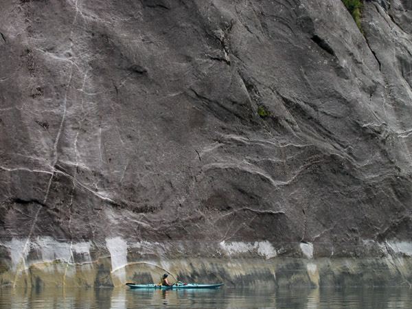
We spent the day in Walker Cove, in the heart of the Misty Fjords National Monument. The sun beat down on us for the third straight day, and though the fjord was cloaked in a light sheet of haze, it was decidedly unmisty. Despite our continual predictions that we're going to start running into people soon, we had the place to ourselves. Our only visit was from one small seaplane. It touched down, the people inside trooped out onto the floats to look at a particularly scenic waterfall, and it took off again. I could venture that the Misty Fjords is a national monument because the Misty Fjords are steep. The optimist in me says they chose these cliffs and waterfalls for their great beauty, but it is also notable that it would be quite impossible to log in Walker Cove. It's nearly impossible to even land a kayak in Walker Cove. |
|
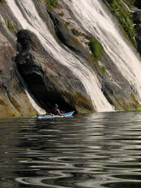
The topographic lines blur to a mess of brown on my map, where the cliffs rise to thousands of feet virtually right from shore. And where there are cliffs and snow above them, and a beating hot sun in the sky, there are waterfalls. Gorgeous waterfalls. Small gurgling splashing waterfalls, waterfalls hidden in slots in the rock, waterfalls streaming over cliffs, gushing out of canyons, and waterfalls so tall that it is impossible to fit the whole of them in one picture. When we paddled close to the rocks, we couldn't even see the whole of the falls. |
 |
 |
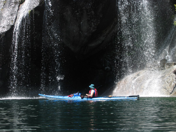 |
We have pictures of big waterfalls and small ones, pictures with and without kayakers included, pictures from close up and far away, panoramas, pictures of us ducking beneath the spray of the falls, and pictures of pretty much everything else in Walker Cove. It's been 3 days, but who knows how long this sun will last? |
|
 |
 |
 |
|
It was dead calm in the middle of the cove, but at each gully or slot in the cliffs there was a crash of water, and a blast of cold air funneled down from the mountains above. We welcomed the breeze, and the bits of shade provided by overhanging rocks and trees. The cove was full of seals, eagles, and sea stars near the mouth. Orca whales passed by in the canal tonight. The first time we've seen them here, and I hope we will again. | ||
6/19/04 - day 11 | ||
Last night's spot on Behm Canal afforded us our view of the orcas, and a crashing of waves. It wasn't a windy day. The waves were small. But they came in crashing, all the way up to the high tide line a few feet from our tent. Niki says she was kept up until the tide went out, with all the crashing and booming, clacking and gurgling. The tides are not our friend. However we time it, at least one direction from every stop is a long haul over seaweed-covered rocks, carrying the seemingly always heavier kayaks. My paddling muscles may be stronger, but my boat-carrying muscles don't seem to be. We set off late across the channel, in a Saturday morning rush of traffic. Two float planes zoomed down and took off, and a motorboat cruised up the channel. It was again brutally hot and sunny, leaving me to wonder where all the supposed seven inches of rain in June come from. I'm sure I'll later regret speaking too soon on that account. A distinct line of no obvious origin separated the darker water on the east side of the canal from the lighter water here on the west side. I remember noticing it from my lofty view on my hike as well. We paddled in small choppy waves which were nicely at our back, in the glaring hot sun, down the other side of the channel. This marks the start of our many planned zig zags. And the whales came back. Not one or two like we saw last night, but a pod of them, moving down the channel alongside us. They surfaced in a tightly choreographed line. First the closest fin would rise with a whoosh of expelling air, then the one just beside it, then the one just beside it, until the whole group of them had risen and dove in their staggered cluster. They were close. Not close enough to photograph, but very close for watching. There were big ones and small ones, and sometimes when they came up they'd slap their flukes on the water with a loud crash. |
||
 |
But we left the whales to enter Manzanita Bay. It's too shallow for them in here. I can hear the whooshing of blowholes from the channel, but they're out of sight. Our plan was to eat lunch, hike the trail to Manzanita Lake, and come back to sleep. This plan was interrupted first by water, second by confusion, and finally finished off by the heat. |
|
I should know by now not to trust where they mark trails on a topo map. Particularly a large scale topo map, and probably also an old one. It showed the trail leading roughly from a "cabin" at the bay to a "cabin" at the lake. So we found the first "cabin", a 3-sided shelter near the beach, and settled down to have lunch, only to realize we didn't have enough water for cooking. That's ok, we'd get it on the trail and cook later. There was a short note scrawled on a board in the shelter: "Manzanita Lake ok - 6/11/04". Finding this encouraging, we fastened up our hiking shoes, lugged the boats above high tide, and set off on a meandering little path from the cabin. It was a rough little track with a few cut sticks near the beginning, and then no cut sticks, and then only interspersed patches of trail, and then clearly no trail at all. One suspicious little dash mark on the map made me suspect it might join up with a larger trail later, and we had to paddle somewhere for water anyway. So we bushwhacked back, noticing the oppressive heat all the more for our movement. It must be hotter today than on any other day so far, surely hotter than when I went hiking at Saks Cove. |
||
|
Around the point we found a sign and a stream. The sign clearly and obviously marked the start of a real trail, which we decided not to follow. After all, it was only getting later, and it was too damn hot. We still have all the time in the world here, so we retired back to our beach to relax, and plan to tackle the trail in the morning. |
 |
|
6/20/04 - day 12 | ||
|
I've taken off all the clothes that I can, I've sunburnt all the newly-exposed skin, and sweated out at least a bucket of moisture. It's still hot. It's unseasonably, blisteringly, incongruously hot in our rainforest. We may end up worried not about running out of food or stove fuel, but of running out of sunblock. |
||
We set off on the 3 mile hike to Manzanita Lake at 8:30 in the morning, sure that it would be a cooler time. But 8:30 isn't that early when sunrise is at 3:30, and it quickly becomes later as you walk. Soon enough, we were pretty much hiking in our underwear. The trail must have been made in the old heavy-handed days of trail construction, when labor and money must have been easier to come by. Practically half the trail was on boardwalk steps over streams, on swampy meadows, and nailed into logs. Some logs stepped had grippy stuff nailed on top so no one would slip, and there were handrails in places and a big log-step bridge and ladder over the lake outlet. I wonder how many people have to walk on such a trail before the effort of construction is outweighed by the effort saved in walking on the trail. The trail may be old enough to have paid itself off in that way, but it doesn't look as if it gets much use now. I wouldn't be surprised if the two guys a week ago were the only ones all year. |
 |
 |
 |
There was a cabin on Manzanita Lake, though we never saw it. It wasn't at the end of the trail. It took us awhile to even find the end of the trail, and when we did, we found the Manzanita Lake Cabin rowboat. It was an old weather-beaten rowboat with rusty oarlocks and "USFS - Manzanita Lake Cabin" painted on its side. The oars were underneath, and it was tied to the trail post sign. I just couldn't resist. Even though we've just spent the last week and a half in boats, and even though we've been lamenting carrying boats for the whole trip, we just had to drag this thing into the lake. So we had an excursion in another sort of boat. We never made it to the cabin (too hot, and creaky oars), but rowed out to a patch of shade by an island and lounged. It was silly, but fun. My only complaint was the oppressive and unbearable heat on the walk back. I've migrated north for the summer, but it seems I haven't gone far enough. |
|
|
We exchanged rowboat for kayaks, and paddled across the channel in the glassiest dead calm water I can imagine in a channel two miles wide. At least it was cooler on the water. Now we're back on the east side of the channel, in Rudyerd Bay, where the supposed throngs of people go. There's a motorboat parked at the end of Punchbowl Cove here. And we're camped in an established-looking campsite. Given that the cliffs on the other side of the Punchbowl rise 3000 feet in short order, and that rocks and cliffs are the norm around here, I imagine that almost any possible campsite in this "popular" bay will look established. The only other sign of life is a profusion of sea stars, with sea urchins near the bay mouth. It will be interesting to see if they disappear as we paddle further into the bay. |
 |
|
|
I continue this entry at 11PM, in our tent, fueled by a rush of adrenaline. Tonight, rather than and out-of-the-way rocky beach, we're in an established campsite. And tonight we were visited by a bear. I saw nothing, but just out of sight, a large snuffling crashing animal moved around our camp. I heard it make snuffly, almost sneeze-like sounds. I heard it crunch through dead branches, and crash around by our kayaks. Niki speculated that the kayak may smell like the peanut butter we carry in the hatch during the day. We hooted and called at the bear, hoping it would run, and telling it where we were, which I'm sure it already knew. It didn't leave. It kept snuffling and crashing, moving around but getting no closer or further from our tent, with its flimsy protection of nylon and screen. I thought I caught a glimpse of a light patch moving through the woods. I sat at attention with bear spray in hand, alternately removing the safety wedge, deciding it was silly to do that before I could even see the bear, and then hearing a closer-sounding crash and popping it out again. We're on the mainland now. It could be a brown bear or a black one. It was rooting around here for a good five minutes, which seemed much longer. We haven't heard anything for awhile now. I don't think it made it over to our Ursacks. I hope it isn't coming back. I think I can maybe sleep now. |
||