Summer 2001

|
|
|
|
|
The Journey
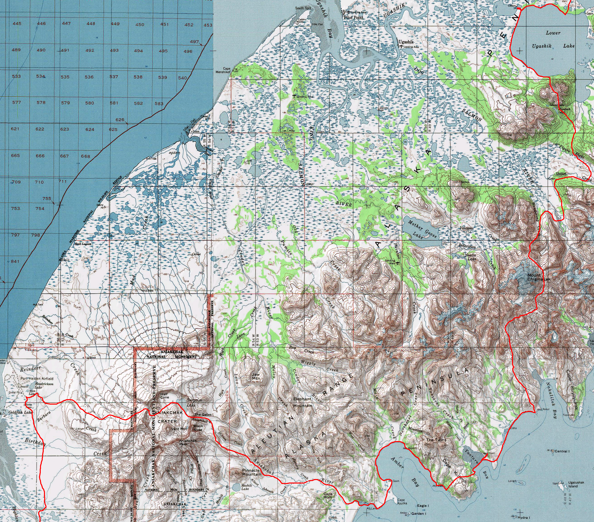
The Alaska Peninsula:
The Alaska Peninsula makes up the southwestern corner of the Alaska mainland, and ends in the Aleutian islands. It is part of the Pacific "ring of fire" and is notable for its volcanoes. This region is home to one of the highest concentrations of brown bears in the world, feeding in the rich salmon streams. We kept a tally as we walked, and counted 85 brown bears seen, plus a few black bears near the beginning of the trip. The peninsula has a cool, temperate climate, marked by high winds near its end. From June 22 to August 23, we encountered only one night below freezing, but quite a bit of rain and wind. The vegetation ranges from spruce forests and thick brush near the base of the peninsula, to tundra and swampland nearer its tip.
As in most of Alaska, there are no established trails on the Alaska Peninsula. We hiked along beaches, lakeshores and gravel bars, through spruce forest, swamps and snow-covered valleys, in cottonwood forests and alder thickets, over rocky passes, on mounded tundra and barren volcanic terrain. We drifted down rivers in packrafts, and paddled across lakes and bays. We walked through one volcanic crater, and past others. As we walked down the peninsula and into the summer, trees and snow disappeared, to be replaced by tundra, swamps, and ripening berries.
We saw brown bears foraging in tidal flats in June, feasting on salmon in July, and eating berries in August. Small groups of caribou crossed our path frequently, along with a few moose. Ptarmigan burst out of every bush, ground squirrels made tiny trails in the tundra, and salmon filled many of the streams.
At times we were watching wildlife, eating berries, or admiring the scenery under a bright sun. At times we were almost hypothermic in blowing rain, desperately holding our tarp down against the wind, almost being charged by a mother grizzly, walking without a map, or running out of food. At other times, we were doing some of both. It was a great trip.
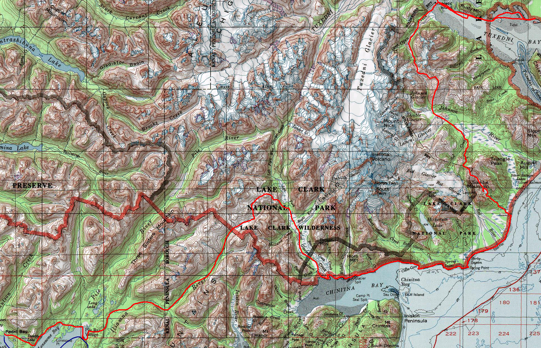
Our route took us between the Drift river near Redoubt volcano and the town of Chignik. We estimated the total trek to be about 800 miles over 63 days, broken down into 7 legs. Each leg took us to a town or lodge to which we had previously mailed a box of food and other resupply materials. At each stop, we met wonderful people, many of whom were kind enough to offer us their food, their homes for a night, or a place to wash ourselves and our clothing.
For each leg of our journey, I have included a rough map of our route, a description, a few pictures, and a selected journal entry. The full set of journal entries can be downloaded here.
contact me at mckittre at gmail dot com
| Leg 1: Drift river to Tuxedni Bay | ||
|---|---|---|
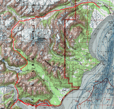 Around the volcano.
| ||
 Walking upriver on the Redoubt Volcano debris flows |  Brown bears have larger feet than I do | 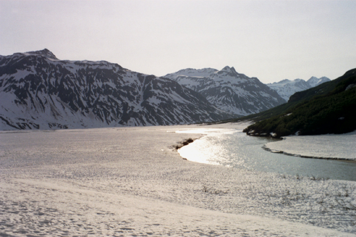 The upper Drift river valley, in snow |
| Journal entry 4 - 6/25/01 (day 4) | ||
| Around a river and through the snow | ||
Now that I've finally laid down, I realize that I'm exhausted. We're slightly behind our estimated schedule, but we're well up the pass and not too far from the top if the walking keeps being smooth. (Actually, Hig just corrected me - we're just across the valley from the planned spot) We woke up this morning to finish our walk on the beautiful shelf overlooking the gorge, scrambling over an immense mudslide which was crumbling over leftover miniature ridges of snow. And then, of course, we hit a cliff. The snow sloped down gently to the raging river below us, then promptly disappeared as the waves lapped against the rock face ahead. No way past but a steep alder traverse over the cliffs. We spent about five hours covering a map distance of about 800 feet. Though it's about a mile when you count the elevation change, and probably at least five if you count all the clambering up and down over trees. Alder are frustrating, but they seem much more kindly when they are the handholds on a steep slippery slope. My feet stick better to the ground than they used to. More practice and more loosely tied shoes. It seemed fine when we were thick in the trees, swimming through alder, scrambling across a little gully... But then there started being open patches. And we had views! Rushing river just below our feet but so far down! It was terrifying! (though actually not much worse). We belayed eachother over one wide snow traverse - not because it was so hard to walk, but because the thought of sliding off it was rather unnerving. I very carefully ignored the wonderful view to focus on my feet and my ice axe and the rope in my hand.. Eventually we shot down a snow chute and across the river on an enormous snow bridge. We'd just climbed up the other side when we heard a vast deep crashing thumping sound. We'd heard a few before - big snow slides. We were just in time to see the one other (much smaller) snowbridge crash and crumble into the river downstream of us. The timing would have been all off without that 5 hour detour. :) We took a whole series of pictures of it. Using up film too quickly on these sunny days. The tributaries coming in upvalley of that were almost all bridged by snow and the other was doable. Almost the whole walk from then on was in snow. Soft, squishy, with deep suncups and actual slush pools in places. It was a good leg workout charging through it, but it felt so nice to be making progress. But I guess we're always making visible progress. Either I can't see very far and am moving very slowly (nasty bushwhacks) or I'm moving fast with a huge vista. Either way, progress relative to the landscape isn't so bad. I think we saw a wolf down near the end of the pass. Too far away to be sure, but it sure looked dog-shaped in the bushes. A lot of neat mud upwellings there from an under-snow mudslide. Pretty orange-brown snow. The Drift river grew more stately as we walked upvalley. Wide, slow, and braided into a million different channels. But we tuned away and took off up this pass. Climbing, but in nice snow. Quite fast. It's exciting to be out of that valley in a new place. The voles are enormous and bold here. Hig's worried they'll chew up all our gear as we sleep. | ||
 Crossing the Crescent River |  Looking across Tuxedni Bay to Mt. Iliamna | 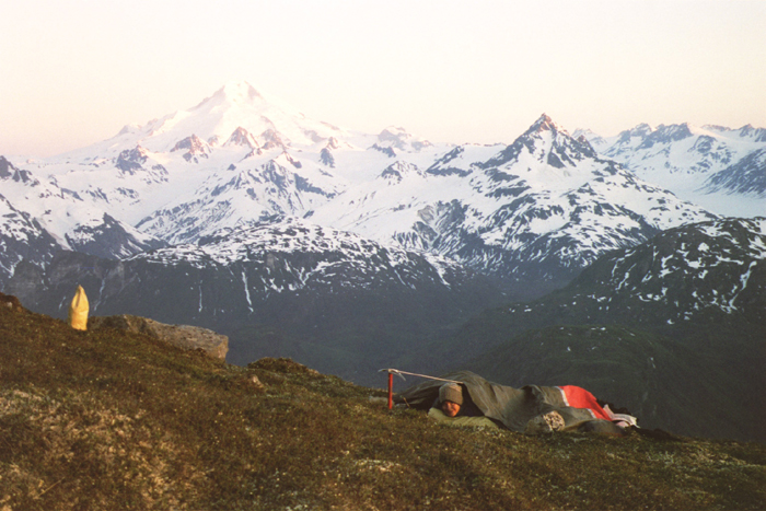 Campsite on the ridge above Tuxedni Bay |
| Leg 2: Tuxedni Bay to Pedro Bay | ||
 | Around another volcano.
| |
 The plane is buzzing the bears on the Tuxedni Bay tideflat, just before we walk through |  The beaver's dam is often the only way around his pond | 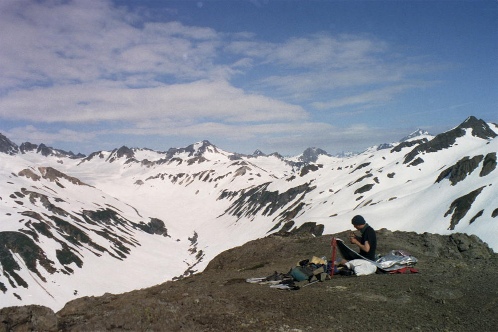 A cold camp with a view |
| Journal entry 12 - 7/5/01 (day 14) | ||
| Obstacles | ||
Well, we haven't written for awhile here. Two long hard days, with little time to do anything but sleep and walk. We woke up two days ago to find that the weather, for the first time this trek, was not sunny. It was foggy, drizzly, and wet. Very wet. Slogging through wet bushes creates a personal all-direction rain shower every time you touch anything. So despite the raingear, I was soon drenched. And the fog didn't help much for navigation. We came down the slope and then cut around the base of it for awhile, debating whether the cottonwood stripes would provide better walking. They did for about 10 feet, but soon we were in a mess of willow, which were even wetter than the alder. There were several large swampy wet meadows and ponds made by beaver dams, and the willow grew thickly in the low spots around those. A great place for moose. We saw three huge moose browsing in the valley below us just as we came down off the hillside. They seemed a little disturbed at our presence and slowly retreated further into the brush. We kept slogging through wet brush, getting quite chilly. It was hard to keep my directions straight in the flat foggy valley, but we kept heading towards the stripe of cottonwood we hoped marked Red Creek. More moose sign in the valley. We found a huge antler, not even damaged, but it was a little too big to fit in our film canister "souvenir case". And the moose trails helped us out as well. They may eat willow, but they do try and walk around it sometimes. And we followed a beaver dam around the edge of a pond. Beaver dams provide great walkways in very wet places. After we crossed Red Creek we lit a huge fire to warm ourselves up and have a meal. Standing there in the cottonwood forest steaming as the water in our clothes evaporated in the fire's heat. The side of me facing the fire quickly became dry and too hot, while the rain spattered and chilled my other half. Hig had an interesting time drying out his wet kit stuff by the fire in the rain. It was hard to leave that warm place. Our plan was to head up the ridge, across another ridge, and over a pass on Saddle mountain. We did eventually do that, sort of. The ridge going up was a real knife edge - narrow enough in spots to be rather unnerving. And it just didn't widen. It went on, sharply cutting its way up the valley only to disappear into a confusing mess of ridges and gullies and cliffs. At least it was snow up there, so we had less of an alder bushwhack. But the place was all gullies. It was a maze. Like the Badlands, plus alder and snow. We kept climbing up and down these bumps, which were smooth on one side and cliffs on the other, often with only a narrow steep strip of snow to ascend them. We couldn't see far enough to tell which way to go. We never did hit the middle ridge, but the pass at the end, which we feared would be hard to find, presented itself nicely. And we started climbing out of the clouds! At first it was a barely perceptible bluing of the sky above us and a brightening of the snow, but soon we could see the sun. The sun on top of the clouds across the valley made a beautiful and mysterious scene - reminiscent of alien spaceships landing. The pass was easy, if a little steep and vertigo-inducing. We cruised down a narrow canyon of a gully on the other side of the pass, carefully inching our way down the steepest part and contemplating the tracks of a mother and baby bear careening down the slope. A lake filled most of the valley below us - mostly covered with cracking and melting snow. We started traversing around the right side, cutting steps in the snow and scrambling up into the alder. I've cut an awful lot of snow steps lately. We got about halfway around when we saw a sticking point ahead. A cliff. It looked like there just might be a way around it, but it was too dark to see from where we were, so we decided, foolishly to continue our traverse around to have a look. Of course, it was at this point almost midnight. We found that that place was impassable, but Hig though he saw a way up at the top of the shelf, so we began to scramble up a steep patch of alder up to it. Soon enough we realized that it was much too cold, late, and dark to do any sort of climbing, and retreated sheepishly back to camp on a huge flat boulder in the snow. The next morning, we started out around the other side of the lake. No cliffs here, but a lot of steep snow traverses and steep boulder fields. At one point I slipped, and started careening horrified down to the edge of the lake, but I managed to stop myself well above the shore. Go ice axes. I would have been rather cold and wet, and it wasn't the best place for fire starting. Instead of a stream coming out of the lake, there was a field of enormous boulders, all the way down to the edge of the spruce. The water kept below them mostly, poking up now and then as we got further downhill. It was even a worse maze than the day before! The boulders made a series of random little cliffs and holes to be avoided, and it was impossible to choose a route more than 10 steps at a time. We managed to piss off a black bear on that slope. It was standing on a rock well uphill of us, yawning in distress and stomping its front paws on the ground as a threat, like it was trying to scare Hig away. I was uphill of Hig at that point, and when I popped out on another large boulder it seemed to decide that two of us was too many, and started retreating. There was another bear with it, and they watched us for quite awhile up there. The boulders disappeared under the alder, which did not make travel any easier. We jetted along in occasional flat spots way down low, then hit another patch of boulder climbing. The boulders were very cool, for all their inconvenience. I was really looking forward to the line of spruce I could see ahead of us, since in my previous experience I had learned that spruce made pretty good walking. But most of the spruce here had been killed by beetles or something. It was all deadfall and devil's club, with the occasional live tree. The patches of alder, which we usually take great pains to avoid, were infinitely more pleasant than the rest of the forest. We had about a mile and a half of that stuff, slowly inching our way along, slipping into holes between dead logs obscured by the masses of green devil's club leaves. Our slow pace made us a great target for mosquitoes tagging along. Although it certainly seemed endless - that forest did end, and we found ourselves in a huge wet swampy meadow. A bit sinky and squishy and mucky. In places pretty. I wish we'd been there later in the year to eat the berries! The horrible bushwhack was full of almost-ripe huckleberries and salmonberries, there were lots of green currants, and the marshy meadow was thick with cloudberry (nagoonberry really) plants. We were surprised to find a well-cut trail heading out of the meadow, through a small patch of forest and past a complex of chicken-wired houses to the beach. Always kind of strange to hike in from the middle of nowhere and see buildings. They were home but not talkative, so we took off down the beach. A nice long straight beach. The wind was chilly, so we put on our fleece jumpsuits and kept walking. We crossed two river channels at the beach, where they spread out wide and flat in the sand and gravel. Cold, but no more than knee deep. Fast going on the beach. We kept walking and it got a little darker, and a little darker. We were heading out to a point. We were rather nervous about camping in grizzly country, and hoped there'd be a better place out there. I felt like de-gritting my shoes out of the wind somewhere, and we were curious about the forest, so we headed inland. The forest had no undergrowth but moss, and a very well-trodden bear trail running along it. The forest was only a thin strip, so we cut through to a meadow beyond, and another bear trail. We hiked along in this meadow for a long time as the channel in the middle became a slough filled with water, hardly noticing the failing light. Suddenly we heard a splashing sound as a grizzly bear retreated across the slough in front of us. Three bears out of nowhere! How could we have missed them? I took the duct tape off the bear spray as we waited, nervously. They retreated a bit further and we decided to walk back out on the beach, where there was more light. We crossed one more little slough and picked our way out to the point, where we found a little sleeping spot under a spruce at the top of the beach. It was probably after 2 am by the time we got to sleep. The sun came out this morning as we were packing, and we decided to build a big fire, eat some, and dry out our gear. A late start walking, but hopefully we'll still get a ways. | ||
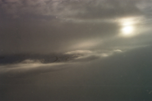 The sun and Mt. Iliamna, peeking through the clouds |  Alder and devil's club in the gap between boulders |  Raft crossing under Mt. Iliamna |
| Leg 3: Pedro Bay to Kulik Lodge | ||
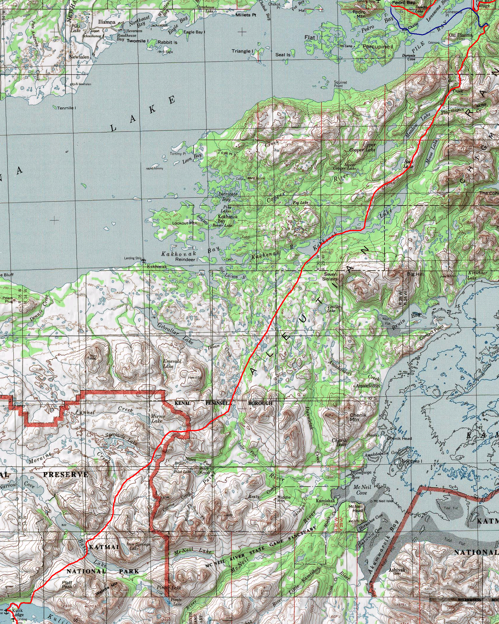 | Great people in Pedro Bay gave us a bed, and food, and ride across the lake on our way out. We made an auspicious start to this leg by managing to walk in a complete circle while following the Iliamna river downstream. That night, we killed our (theoretically waterproof) camera in a rainstorm, which would not be resurrected until our next leg. This is where we noticed the terrain really starting to change. The spruce forest faded away, and we found ourselves in a country full of lakes and low hills of tundra. Walking through blowing rain across the expanse of tundra made us feel very much the intrepid explorers. As we got further in our journey, the terrain was less and less familiar, and everything around us seemed unusually large. The end of the leg took us through a series of low mountain passes, where we saw our first caribou of the trip. Ptarmigan were everywhere. This journal entry is written just after our descent from the mountains. | |
| No pictures for this leg - camera got soaked | ||
| Journal entry 18 | ||
| A long day in the high country | ||
|
The last time I wrote in here is 53 miles and 3 days behind us by our reckoning. It's sunny (somewhat) today for the first time in awhile. We've had blowing rain and mist and fog, making our trek seem all the more intrepid. The country has changed so much. There aren't spruce here. We've crossed vast expanses of open tundra with alder in the wind-protected spots and open tundra and snow up high. It was a surreal journey yesterday. We woke reluctantly in our bed of cold wet mud wishing we'd set up the campsite better. We weren't exactly in the mud but we were in a good deal of water, draining into our rafts and soaking into the sleeping bag. Later, Hig hung that blanket out on his pack like a wedding train while we walked. We had a maze of little bushwhacks and open spots getting up to the ridge and then we took off. Weaving around through passes up along slow ridges and across huge flats of boulders, tundra and snow. The scale was disorienting. At one point, we were descending a long snow slope down from a ridge, looking at the stream and little pond just below us, but then we noticed that the white of rapids looked odd in such a little stream and realized the whole view was much farther and larger than it seemed. All the little streams were running in flood up there, as they were in the alder the day before. Little stairstep waterfalls running over grass tussocks, spreading and joining in channels in the grass and tundra. There were ponds formed in the low spots between tundra mounds that bubbled up as we stepped beside them. We have no pictures of that place, and its hard to paint a picture with just a few non-edited words. I can think about my sentences as I prod the fire under our pot here. Cooking two meals at once to save on time and make use of the dry alder here. Trees and wood are disappearing as we walk. I wonder if we'll have trouble finding cookfire wood. I have a well-oiled page now from a messy encounter with the tomatoes and oil. Once we got up into the tundra yesterday we went so fast and so far. And everything was big. Not just a big expanse of mounded tundra like the day before, but big with enormous smooth mountains and ridges and lakes. There were boulder fields at first. Huge flat fields of grey boulders spotted with black and fluorescent green lichen, with water sometimes running underneath. The boulders vanished somewhere in the middle of the day that I don't quite remember, to be replaced by small gravelly piles. The magenta bell-shaped flowers were everywhere in bloom, making pink stripes on the hillsides. We climbed one long incredibly smooth slope that was full of them. And when we were almost at the top, we saw a herd of caribou. 14 of them, with two babies, looking elegant and almost silly, silhouetted against the snow with their long skinny legs dangling from their bodies. They were split into 3 small groups and when they noticed us, each group moved as a strict line. Moving, looking at us and the other caribou, moving some more, slowly edging towards eachother until they were assembled into a herd. And then they trotted off up the snow away from us. We saw more tracks and 3 more caribou lying in the snow this morning. I wonder if they were too hot? We accidentally climbed 400 feet out of our way to see that first herd, but they were worth it. The clouds were just above us for most of the day yesterday and they kept thinning and thickening as we and they moved, providing a shifting mysterious view of the landscape. We didn't really know how far we'd come, but shortly after the ridge we decided to allow a little more food for the day and just go for it. Nearly walked Hig's feet right off. He didn't stop to fix them soon enough, and much of their surface is covered with several large and nasty sores. Hopefully this mornings bandaging will work out. Near the end of the day we had a walk right in the clouds, allowing only a small and vague view of the world beyond our angled snowfield, and making everything more somber and surreal. We were pushing a bit too hard at the end maybe, especially on Hig's poor feet. And shortly after our last river crossing, he just crashed. We found a nice campsite in the alder above the gorge, but our sleeping bag wasn't totally dry yet, and it was a cold night. We scared up a bunch of ptarmigan again at our campsite and on the descent to Battle Lake. So many ptarmigan. None up high, but all over the place in the alder and tundra country around here. Hig tried to kill one with an ice axe toss a couple times on the way up to all the passes, but only came close once. A ptarmigan would be a mess to deal with anyway. We were a bit worried about the wind and barely breaking whitecaps on this Battle Lake crossing, but it was hardly rough at all, and the wind serves only to drive away the bugs at our cook spot here. Now we go up over another long smooth high spot, and down to Kulik lake. A short day tomorrow, perhaps. | ||
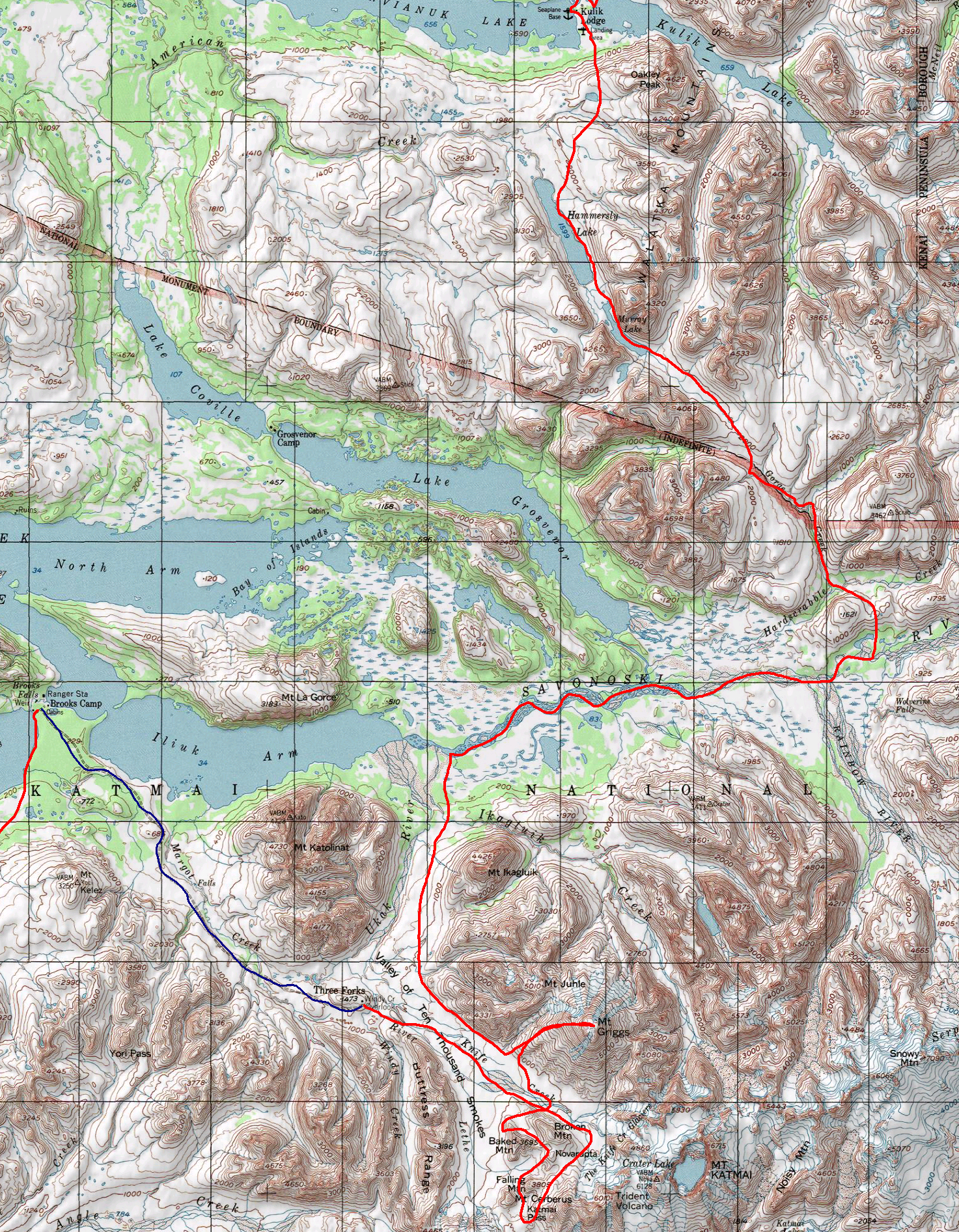 | We only stopped briefly at Kulik Lodge, so by the end of this leg it felt longer than I had ever hiked before. Our confidence increased as we went along. We had always told people rather cautiously that we were headed to Chignik, with no real conception of how likely or possible that was. Here at the midpoint, we began to believe ourselves. | |
 A bear trail> |  Bear along the shore of Hammersly lake |  Warming up after floating down the Savonoski River |
Journal Entry 23 - 7/25/01 (day 34) | ||
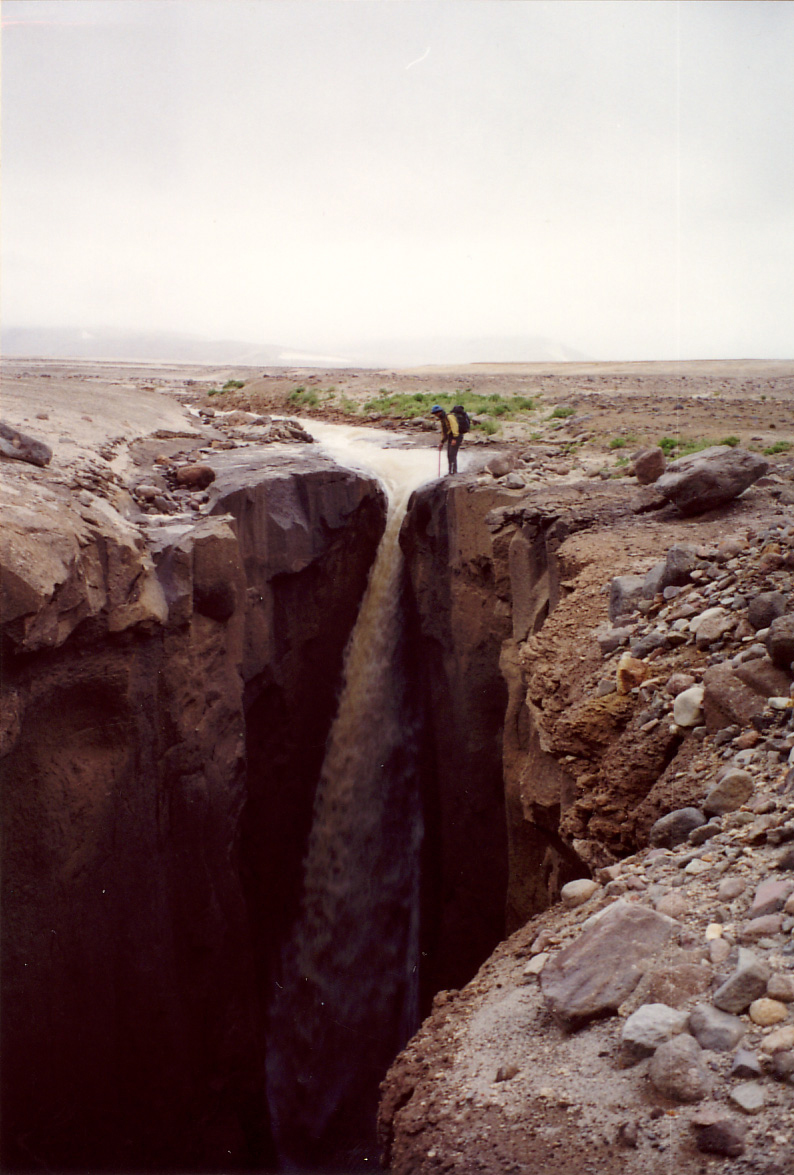
The Valley of 10,000 Smokes | ||
|
Using Hig's almost dead blue pen, since I can't seem to get the black one to work at all anymore. Hopefully the pens are being resupplied in our next box here. I'm writing from just above the clouds on top of Griggs mountain. It's certainly the highest point on our journey - over 7600 feet. And not particularly on the way to anywhere. We're just going to go right back down and head across valley to where the USGS camp is marked. This is the part of our trip where we get to stop just traveling and poke around some. The valley of 10,000 smokes is just awesome. We'd been bushwhacking on and off all day, through patches thick with willow brush and a few big trees, down into lower marshy spots with cotton grass, moss, blueberries... We got derailed several times by patches of ripe or almost-ripe blueberries. Maybe that's what made Hig's stomach feel funny, rather than the possibly rancid gorp. I tried a sliver of one of those hamburger bun mushrooms that Hig suspects are edible. Hasn't killed me yet, so I'll have to try a bigger piece next time we run into one. Which probably won't be for awhile. I was getting a bit tired of the brush and the marsh and the little bugs banging me in the face, so I decided to head straight off for this funny little hill of sand. After being sidetracked by geologist sign on the cut bank of a stream, and derailed by a few ripe cloudberries at the edge of the marsh, we mucked our way over to it, climbed over the edge, and were astounded. It was like we had walked straight off the face of the earth, from brush and marsh into barren windblown flats of pumice, sand, and gravel, with a few bushes and small green bits of plant struggling to survive. It says on the Katmai map we have that "normal stream crossing procedures do not apply" in the valley of 10,000 smokes and that we should be briefed by a ranger in Brooks. Even though we'll hit Brooks near the end of our stint in Katmai I'd be curious to see what they'd tell us. All the streams were in deep narrow gorges, knifing through the flat valley above. We couldn't see them until we were almost on top of them, and in places a bolder person than I might have jumped across a hundred feet of drop. The walls were cracked in columns in some places, smoothly carved in others. Beautiful red colors in some of the rock. And poking up from this desolate plain of deep gorges were normal-looking green-sloped hillsides. The clouds are eating us again on our mountaintop hangout. The view over the clouds is really neat when you get it. Almost like an airplane view, over a flat plain of puffy clouds with an occasional far-off peak just barely poking through. Unfortunately Griggs here seems to like to wear its very own hat of clouds above their main expanse. The way up here wasn't as grueling as I expected, even with the 6000 foot-ish climb from our campsite. Strong legs and end-of-leg food quantities to carry serving us well, I expect. All barren on Griggs. Some sand slopes, scattered rock, snow, remains of old lava flows. Some of the sand is sinky and makes climbing hard, but our way down should be softer and more pleasant. We smelled a strong sulfur stench at the end of the steep part of the peak, and saw yellow stains on a lot of the rock. Climbing up to this peak ridge we crossed a snow crevasse that made a beautiful cave with dangling icicles. We've been taking a lot of pictures here. I hope some come out. I ended the last journal entry at a fire by the Savonoski river. We had one more fire that day. Rafting along in the cold drizzle the river looked large and ominous around me. And still more than a little frightening, with its fast-approaching rapids and snags, threatening to capsize or puncture our little trail boats. But all were easily avoided, and the boats are anyway quite stable. Eventually we had to stop. We could barely even walk across the one little channel we had to, and we decided to warm ourselves up with a big fire. It was very big. I collected an enormous pile of wood to keep warm while Hig started it, and we ended up just using it all. No more cooked meals, but we decided to have warm soymilk and cookie crumbs to get some of that nice fire warmth inside of us. We were surprised that it was already 9:00, and just couldn't figure out how that happened, but we decided to just camp in some trees on our island. The next day was a much sunnier day for rafting. We zipped along the river, despite the headwind. Hig gets blown by the wind more than I do, so I kept drifting past him. Channel-choosing and log-avoidance were still important, but got easier as the water calmed. The park map mentioned that you shouldn't camp on the lower Grosvenor or Savonoski river because of the bears. And sure enough, after the confluence with the clear fish-full Grosvenor, the right riverbank was grizzly central. We saw 18 bears, mostly lounging and sleeping on the shore. Two were in some odd configuration playing, with one grizzly foot dangling in the air. One bear even ran from us, but most paid no mind. I guess the salmon come up and head for Grosvenor lake, so you see no fish and no bears in the Savonoski above that. Although you see bears in the funniest places. There's an actual trail going over the pass next to Griggs into the valley of 10,000 Smokes, and there's nothing growing here. We won the prize for a fast camp setup (half hour, but we did it in 19min) last nigh, and the prize for breaking 6000 feet today. After the river got so slow that the wind was a major impediment, we landed the rafts, took a Hig shoe-repair break, and we took a compass bearing off into the woods. There was a real non-beetle-killed spruce forest there. So pretty, and with lots of fluffy moss underfoot. There was a stream marked in our path on the map that wasn't just a part of the Ukak river. Hig glanced at it briefly and thought it just came down the other side of our valley. A little stream. We hadn't yet switched over to the detail map. But it was a torrent. It had a huge drainage from the next valley over. And it was just barely foot crossable. We were able to take advantage of a spot where the river wanted to turn sharply, and spread out down over a shallow spot. We went slowly and carefully, but it was definitely the most hardcore river crossing I've done. We slept in the spruce, and I lost and found the Ursacks in the confusing landscape of widely-spaced similar trees and low brushy meadow. | ||
 Hig looking into a gorge | 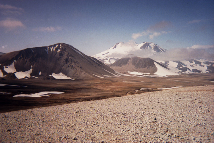 Mountains in the Valley of 10,000 Smokes |  Mount Griggs |
 | Brooks Camp was perhaps the oddest place we stopped on the trip. In the middle of a mostly-empty Katmai park, Brooks Camp is a zoo full of fishermen, hikers, and especially bear photographers. The bears came closer to people there than anywhere we'd seen before. The camp is dotted with designated viewing platforms, and rangers direct people traffic to avoid the latest bear locations. | |
 Rafting across a channel on Becherof Lake |  Mt Peulik and cottongrass |  Sunset over Mt Peulik |
| Journal entry 26 - 8/5/01 (day 45) | ||
Bear encounters, breaking paddles, a salmon feast and gorgeous volcanos | ||
|
This leg has been short on journal entries. It's our last cookfire, and hopefully our last day if we can make it that far. We weren't actually planning to cut back to the beach quite so soon, but figured we'd better leave the ridge to the browsing grizzly. 74 now. We upped it some on Becherof. Quite the place for wildlife. And they're all so curious! The cranes fly circles around us, the caribou investigate cautiously, and we even had a mother grizzly check us out. We were walking the beach near a salmon stream and saw them. They saw us, but weren't moving, so we cut inland to a little knoll. Mom and cub had also cut inland and we saw them ahead of and below us. We looked suspiciously at eachother for a little while, then she sat down, apparently unworried by us, and we decided to angle back to the beach. Mama was apparently less happy about our slight angle towards her, and started loping towards us, baby in tow. You aren't supposed to look at an approaching bear directly, but that was the best eye-corner view of a bear I've had yet. She made a pass about 40 or 50 feet away from us, maybe closer. We just stood there, stock still, talking about how we weren't really a threat to bear cubs... I had my hands on the bear spray, ready to set it off. Then mama must have decided we were scary after all, because she took off up the ridge. Cub didn't follow, and mama started circling back around... We headed for the beach and wished them a happy reunion. The day of the last journal entry was our longest day yet. 24 miles. Walking along in the wind in the surf, filling our shoes with grit with every wave. We were worried about cutting inland unless we had really good visibility because the bears wouldn't be able to hear or smell us in that weather. So much wildlife around that lake, I had to stop and tally it several times between journal entries. Right as it was getting dark that night we came across a grizzly at the mouth of a little salmon stream. We ended up camping on a hill between the two streams, carefully cutting back far enough to be out of the bear zone. We tried for the 12 minute set up pineapple, but couldn't quite make it. 15 minutes was hard, and 12 seem s darn near impossible. I'm being distracted by that meal Hig's cooking. Mmmm... Black beans, sun-dried tomatoes, olive oil, greens, mushrooms... That was good. The next day was actually not quite so windy. We had planned to paddle first thing in the morning, but what wind there was was dead against us, so we did the fast beach walk to the mouth of the big river, all foofed up in all the insulation we could possibly wear. I wear our sleeping bag, wrapped around my chest and tummy, and Hig wraps himself in the space blanket. But not 10 minutes after we started out, my paddle shaft snapped on a random stroke, and I had to slowly make my way to a sandbar, where we splinted the thing with a stick, lashed it with the green twine, and duct-taped the whole mess together. We had a curious caribou watching as we set up our rafts. A spy. And after that we just kept paddling. The wind was unfavorable and we were cold and wet, but an army of sandbars prevented us from reaching the shore, which was all marsh anyway. So we did end up cutting the corner to Severson Peninsula. There are a couple of tiny islands just off the shore of the Severson. We were almost at the first one, hurrying to it to give our arms a rest and our boats an emptying there, when Hig's paddle shaft broke just like mine. He didn't want to bother to fix it so close to the peninsula, so we built a couple very short fires with nothing but huge piles of grass. The whole island was thatched with grass, and those little fires warmed me considerably. After our last push to the Peninsula, we built a real fire, had some good food and boiled up some Labrador tea. Hig fixed the huge leak from the emergency deflation ring on my raft where the paddle was tied. We're really appreciating pushki as food now. It's a great celery-like veggie, as long as you're careful about raw juice and sunlight. We walked the ridges after that, but they were gullied and lumpy with quite a few bushwhacks. And the fog rolled in over us, so we walked this way and that along the caribou trails, getting only fleeting glimpses of our surroundings. We didn't make it to the crossing point that night, but woke early the next morning (winning ourselves the up-before-7 prize) and hoping to hit the beach before the wind picked up. We saw a great big moose on our way down. Actually the second moose we've seen on the lake, even though all the sign and antlers seem to be caribou. The wind was snorting by the time we were ready to cross. Huge waves, white-capping a bit in our little channel. I didn't think we had a chance of crossing just then, and started gathering firewood. Hig was skeptical too, but he wanted to check it out and see just how bad these waves really were. And they weren't bad at all. Our little rats bobbed up and down like corks, riding over the top of the waves. We made it to the island with room to spare, and hurried over to the other side. The waves were smaller, but the wind was more against us, making it another long hard paddle. When we got to the other shore we saw a wolverine across the channel, and we'd seen a caribou earlier. Too much sign on the island for a local animal population; they must swim the channels. We built a fire on the sandy point, hoping to keep warm and have a meal. But the wind picked up and just started howling. The fire was a furnace, but it was impossible to keep warm there. We ended up using the hot rocks from the fire and taking warm naps in the lee of the burm. Off to the Gas Rocks. Easy going for quite some time, and we just trucked along the beach until we got to this little salmon stream. It was just a tiny thing, but there were fish there. Hig half-heartedly threw his ice axe at the salmon and waded in after it. But he scared up the fish and started chasing one. Confused by the options of scary thing and shallow spot, it darted right up onto the bank, where Hig was able to grab it. It was a primal scene, hacking up the fish and cooking it over our little fire, eating it with bare hands and a crude willow-branch fork. So good. And we were very hungry. Time is food for us out here, so if we can get some calories to make up for it, stopping doesn't put us behind our goals. We've used up all our easily available fat reserves, and rationing ourselves to 6000 calories a day (between the 2 of us) is not so easy as at the beginning of the trek. After our salmon we played the grizzly-dodging game on that bit of shore thick with salmon streams. That's where we ran into mama and cub, and there were at least a couple other ones. They ran, fortunately. It cleared some where the sun was setting and we had a gorgeous light show, with ringed clouds around Peulik, and great colored clouds elsewhere. We didn't quite make it to the Gas Rocks, but it was a fairly easy walk there the next morning. The first truly sunny day in a long time, yesterday. We went behind the Gas Rocks on the lake side first, then cut up the middle one on a nice little shelf, on our way around we scare up a couple of caribou that were probably coming our way along the beach. One took off, but the other one, deciding that we weren't all that scary, decided to circle around behind us. This big elegant animal, gracefully running past us, splashing in the shallow water of the channel.. A perfect shot, I hope it came out. On top, we had a great 360 degree view of everything. Many pictures were snapped. We didn't see much in the way of gas at the gas rocks, just a few mildly interesting bubbles in the lake. But we went there for the view. And there were great blueberry patches on the other side of the hill slope. Huge ripe berries and easy picking. We took a long break and just filled our stomachs with berries. Easier when my stomach is shrunken like this, but still a lot of berries. The next stop was the Ukinrek Maars - two huge craters from a 1977 eruption. The first one was a perfect crater lake, just classic. Striped bedded walls sloping down steeply to a plane of turquoise water. The second one was also cool, but just had a bit of muddy pond at the bottom. As we were heading to the maars we saw a flight-seeing helicopter buzzing around and landing on all the gas rocks. I'm not sure if they were looking for the best lunch spot or what, but they finally settled down on the 3rd one. It would have been funny to run into them. The cut to Ugashik lake wasn't bad. Some brush, some marsh, but a good bit of tundra. We tried unsuccessfully to catch another salmon at a little stream. Up in the meadows in the pass between lakes there were a million funny little bumps of hills. Something to do with the volcanoes maybe. Once we hit Ugashik we just took off. High-energy walking on the gravel beach, but fast. And unfortunately, monotonous. We had one stretch of beach that must have been 3 miles long without one bend to the coastline. Nothing but gravel ridges, a lake, and a small bank of grass with an occasional bush on the inland side. We walked into the dark and camped at the base of the long peninsula we've just crossed. | ||
 Caribou splashing away from us near the Gas Rocks |  Crater lake at Ukinrek Maars |  Walking down a monotonous beach on Ugashik Lake |
 | This was in many ways a wonderful portion of the hike, and in many ways a fiasco. We had no real map of the area, only a quickly (and incorrectly) sketched coastline of Alaska. Thus it took longer than we expected, and we didn't have nearly enough food. At this point we needed far more than we had calculated, and we had far less. But this also led to adventures in salmon fishing, browsing with grizzly bears, a beautiful coastline, and a trip through the awesome Aniakchak crater. We chose our route mostly to avoid the swamps, and headed up around Mt. Chiginagak (a steaming volcano covered in mineral deposits and caribou) and out to the coast (where the journal entry was written). This was our first beach hiking since leg 2, and the coast was both empty of people and covered with more people stuff than anywhere we'd been. Our route was circuitous, and after our trip down the coastline we headed back across the peninsula through Aniakchak crater. The remnant of a prehistoric eruption, the 5-mile wide crater is still an eerie and barren landscape, with bubbling springs, volcanic rock, and a young cinder cone rising from the middle of the plain. We arrived just before a storm, to see a beautiful light show in the crater, and to weather fierce winds that blew all night. We were nearly hypotherrmic on our way back out the next morning. | |
 Looking back at Ugashik Lake |  Climbing towards Mt Chiginagak | 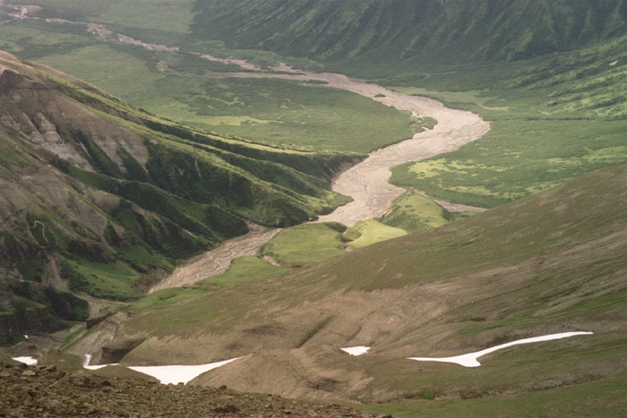 Looking down from Chiginagak towards Mother Goose Valley |
Journal entry 29 - 8/14/01 (day 54) | ||
Hunger | ||
|
Sitting here by our fire on Amber Bay thinking that I really don't want to eat our other salmon. But we're short on food, and this is unfortunately the only good way to supplement our calories at the moment. We purposefully chose a longer route - coming out here to the Pacific coast, and it's been longer than we thought. Our rations are short normally, and trying to go on even less has proved quite difficult. It was a fast beachwalk from our last fire down to the point, then we cut up over the ridge to Yantarni Bay. We didn't realize how late the low tide was, and weren't paying attention or thinking about it, so we dawdled on the ridge for awhile, picking piles of blueberries and lingden berries. Ripe for the first time! Those always look ripe, taunting poor hikers with their red red tops and pale green bottoms. When we got to Yantarni, it looked so small! We headed out down the beach, thinking we'd hit a river channel, but nothing too bad. However, when we got to the water we found that we were on a spit, and the bay was rapidly becoming as big as on Hig's crude sketch of a map. We could have rafted, but the wind was howling dead against us. So we tried wading from sandbar to sandbar, hoping to shorten our way around. And the water got knee deep, waist deep, chest deep... We took off our packs and set them on our heads, and I waded further, with the salt water off my pack blowing and dripping across my face. The bottom was sinky sand, and after only a few steps I found myself shoulder deep, neck deep, sinking down into the bottom with waves splashing my face... I got out of there in a hurry, and Hig did too. He hadn't gone quite as far as I had, but far enough to be thoroughly soaked. We decided that we had finally won one of the first-established prizes - to fall, tip, or otherwise get yourself so thoroughly in the water that your face gets wet. We didn't really feel like walking around the bay at that point. and it was a beautiful sunny day. We decided to try the experiment of sitting for a day, waiting for a lower tide, and not eating any of our hiking food. It was certainly interesting, if not entirely successful. We cooked up the berries with soymilk and sugar, boiling them down for a long time and then drying them slightly into a tart sort of blueberry-cranberry jam. It was quite good, but we didn't let ourselves eat much of it. We did eat a big pot of rather mediocre beach greens - steamed in their own juices for lack of any fresh water. Some were a bit charred. And then we thought we'd go back up the ridge for more berries. But we went much farther inland than we did the first time, and spent a long time wandering around on the ridge finding no more than a handful to fill our very empty bellies. I didn't realize how hungry I was before I started climbing that ridge. Each step up the steep slope was a monumental effort. Breaking now for a salmon-digestion-induced nap... As we were coming down the ridge again it was getting dark. Very dark. And Hig had to scramble back up a little gully to get the water bottle he'd left there to fill. We could have filled up from a pond on the ridge, but didn't think of it. The surreal experience of walking back down the spit to look for our camp with no light and no food, holding hands to help eachother along because neither of our brains were functioning anymore... It was intense. But we built our fire back up, ate the rest of the sklup for the day that we'd meant to save for walking, and curled up by the fire, leaving our food un-Ursacked and our stuff scattered. We hadn't seen bears or bear sign, so it didn't seem that dangerous. We were planning on waking to try and cross at the 2AM low. And we did wake up in time, but man we did not want to get up just then. We decided to sleep off our hunger, to sleep long and late and try crossing in the next afternoon's low tide. We hung out by the fire some more in the morning, Hig went to the channel for water, and I patched my pack. We saw several fishing boats in the bay while we were there. One anchored overnight and another was there for most of the next day, but most were just passing through. I wished I was over there where they had food! We waded across one stomach-deep channel and then reached one that definitely didn't look crossable. But we were in a traveling mood, and quickly set up our rafts and dinked across. Quickly enough, in fact, to win the prize of a fast raft inflation. So we got to actually eat the pineapple for our stupid and our smart attempts to cross Yantarni. There was a neat rocky point on the other side where we gathered mussels and snails and limpets for a little shellfish feast. Funny to be eating fancy expensive restaurant food with your fingers by a campfire when very hungry. I've never eaten so many mussels. They were best roasted right in the fire until the shells were blackened and almost falling apart. The ridge over to Amber Bay was larger than we thought, so we didn't get over that night. The bushwhacking was worst at the beginning, but even after that there were so many gorges to go around. We got to eat our berry jam with granola up on the ridge. Yum! The next morning we spent ducking and weaving our way around gorges, trying to reach the ocean. Eventually, after a great viewpoint and nagoonberry patch, and a short steep hop down into a gully, we were at the beach. Earlier that day we had a long steep gorge full of salmonberries and alder to cross. Hig stuffed himself on the berries, but I just couldn't stomach them, and instead desperately crashed my way through the scratchy brush back up to the tundra on top. So many blueberry plants up there, but hardly any ripe berries. The beach walk around Amber bay was nice. Some bouldery parts, but often with gravel or sand in between. Not too bad of walking, and the slopes were interesting. Crumbling black stuff, then huge blocks of gravel... We found a tangled mess of gill net wedged into the rock and marked with a pile of white buoys. Hig had mentioned wanting one, so we grabbed a couple lengths. And put it to very good use shortly thereafter at a little salmon stream. We strung my string through the top and bottom of the net and tied it to a couple of sticks to stretch it out. Hig had one stick, I had the other, and we waded out into the water, wondering how to go about netting a fish. And bang! Three salmon darted into the net. One was lost as we brought them in, but we cooked up those pinks in a little fire oven, right there by the stream. It may have been better to move a bit - we had some grizzlies come asking after that fish. One stomped at us from across the stream, but then retreated. And they circled around from the other side a few minutes later, before running again. Three total, and they seemed to be together. We got to the river at the end of the day, only to discover that it seemed to be very definitely the wrong way to come from the crater, bending back into Amber Bay valley. Sigh... We were confused. Perhaps we misread the map and the river comes out in Aniakchak Bay? We know the direction to the crater itself from our map, but it would be nice to stop at the river mouth. There's supposedly a cabin, with Jim Gavin in it there, and maybe some food! I hope people don't start worrying about us, taking so long. We're going to climb up to a viewpoint here in a minute to see what's up. We crossed the river we found in rafts and waded back into the water with our gill net. We had to muck around a bit more this time, and only caught one at a time, but we managed to get three salmon. Hig ate one last night and we hung the other two salted in an ingenious (Hig-contrived) contraption of net and raft off the edge of a cliff, which we climbed up next to in the pitch dark. And this morning, we ate salmon. A big one roasted, and a smaller one in soup with beach spinach. I wanted candy and cookies and pancakes and cranberry bread and waffles and smoothies and fruit and cereal, but I did not want any salmon. But we did manage to eat it all, with a welcome break of yarrow tea and creamy berry drink in between. You'd think we'd be hungry enough not to mind, and I'll sure be hungry later, but stuffing oneself with salmon and then walking with no other food is just not the most efficient way to eat. And salmon doesn't have sugars and starches, which we need more of. | ||
 Ridge to Nakalilok Bay |  Cooking in the rain on Aniakchak river |  Light show in Aniakchak Crater before the storm |
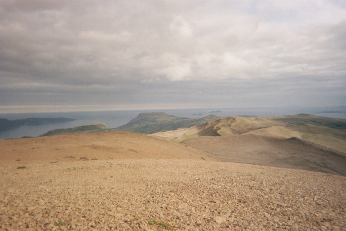
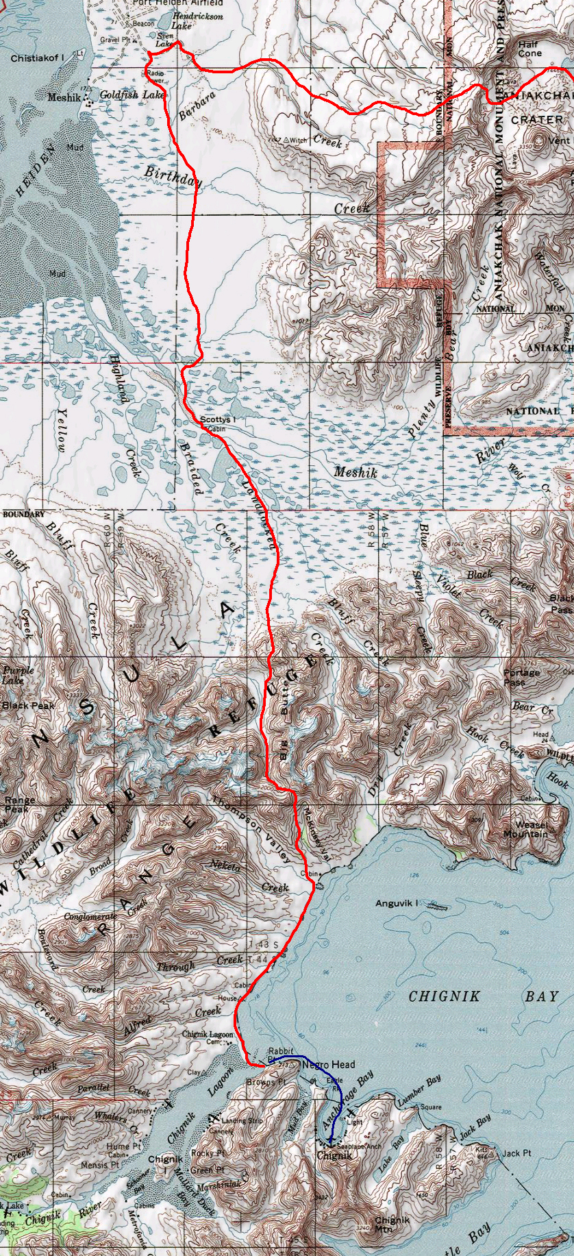 This was the shortest leg of the trip at only 4 days. By this time, we knew we were almost home and were a bit homesick. Missing anything is worse when you know you're almost done. Luckily, we were not hungry for the first time in over a month. We wandered around the small expensive grocery store in Port Heiden and bought the cheapest per calorie food we could find (a lot of frosting and peanut butter, among other things). We had 9,000 to 10,000 calories per day to eat between the two of us. This leg started in the swamp. The north side of the peninusla is low, flat, and swampy. For the first time, we could see all the way to the horizon, with nothing poking up but the few scrubby willow around each river channel. Coming up the Meshik river was an exercise in avoiding deep swampy channels. Although we had just come from the Pacific side, we headed right back across again, over the mountains and down to the sea. There was an awesome field of petrified wood on top of the ridge, and a nasty bushwhack on the way down. The beachwalk was | ||
Looking back at Ugashik Lake | Climbing towards Mt Chiginagak | Looking down from Chiginagak towards Mother Goose Valley |
| Journal entry 32 - 8/24/01 (day 64) | ||
| Arrival | ||
|
Continuing this entry from the Northern Dawn, a fishing tender here out of Chignik. We got a ride out to their boat from Chignik Lagoon, and are hanging out with them (Donny, Wendy and kids) until they head into Chignik Bay for the night. The alder bushwhack up the ridge was actually fun. We shopped in a pretty little stream gully full of crunchy candy flower plants and happy heavy watermelon berry plants, drooping their fruit-laden stalks into the stream. Had a nice break with hummus and crackers, cooling off and rehydrating before our push up the ridge. We had just broken through into the tundra and were still climbing steeply towards the ridge. I was going a bit faster than Hig, so I turned to look back at him and the view. The dog was right at my heels, and Hig was a little ways back... The dog?! A fox was tagging along with me. It stopped to watch, and it trotted ahead a bit, stopping to pee on the tundra, and looking back at me, as if inviting me to follow. I continued with my upward toil and the fox loped easily along with me for a minute, before tiring of my company and taking his own way off over the ridge. We ran into him once more, just before the peak, joining us for another short spell and then disappearing for good. The flat marshy valley of the Meshik looked much more beautiful from above, with the light glinting off a million little ponds and lakes and channels, stretching off into the ocean. Just beyond our rest on the peak we were waylaid again by a great outcropping of petrified wood. Chunks and log just scattered on the dirt, some crumbling out where they stood, others remarkably solid. There were some that looked as though they could be thrown on the fire, and others with wild folds or colors or quartz intrusions. Pretty grain. We had a hard time leaving an especially nice large chunk of wild stuff, but settled for quite a few smaller pieces. On such a short leg, what's the difference? Just beyond the wood we found a funny box of a machine, put there tat year with a solar panel and a bunch of batteries inside. A tube went down into the earth an then into the box. Measuring gas maybe? Natural gas? Volcanology? We followed the ridge for a while longer, skirting around a few peaks, surprising one caribou. It's fun being up in the alpine like that. But the ridges ahead were looking sharper an nastier, and the clouds were thickening up high, so we decided to drop back off the top and take the valley and pass route after all. The bushwhack down wasn't too bad, and the valley below was a breeze. Big gravel flats, open tundra, and even ripe nagoonberries! (which is a sure sign of a route well-chosen). The willow were widely spaced, and the shorter ones showed sign of moose browse. We saw two moose as we were cutting off the ridge, but the valley seemed missed by other wildlife. No bear sign at all, and there were quite a few good blueberries in the valley. Unfortunately we hurried past them on our way to a camp and fire site. Apparently people around here go to pick the little black blackberry/crowberries that grow in the tundra. I didn't know they were considered worth eating, but I've hardly tried them. This time we set up our campsite before we went down to the stream to cook, making it a little easier to drag ourselves from the fire into the cold dark night. The warm rocks we brought to bed with us helped too. And then it was up and over the pass into McKinsey valley. Our gravel flats disappeared after awhile, and we dinked back and forth across the stream, walking in bits of alder, gravel, and meadow until we followed a ridge and a high shelf up the left fork and into our pass. No more brush there, just tundra an talus fields. The rocky slope wasn't as steep or as difficult as it looked from below. After eating our 2-month celebratory chocolate bar, we walked right up it, avoiding a bit of hard and slippery snow near the top. It was chilly and drizzling, and as we descended into McKinsey Valley, we soon found ourselves in a mess of wet alder and salmonberries, broken by much-welcome meadows. Soggy, soggy walking. We followed a somewhat meadowy shelf for awhile and then cut down to the river, crossing back and forth and walking right on its flanks. The alder was less choked with undergrowth there and the bushwhack was even and enjoyable challenge, weaving between the trunks and branches at top speed. We cut back up again before the river gorged up, following a meadow almost right up to the ridge. It would have been nicer walking up there, but we had no easy way to get to it. We dropped down the other side into Thompson valley, and followed the creek out into the bay. So much bear sign around that creek. Trampled ground everywhere, rotting pieces of salmon littering the banks of every channel. And half-rotten fish in the stream, flapping around. All the bear sign looked old though. No fresh tracks or scat. Must be tired of fish by now and off eating berries. We had a bit more of a scramble to get around the lagoon at the mouth of the Thompson, but then, the beach! Almost there. We stopped at the first tiny stream we saw to patch our rainpants while daylight lasted, and slept by the warm fire (gaining seven raft burn holes - which were patched this morning). The sunrise was pretty this morning, with one bright cloud camping over the offshore islands, and rays of light beaming down and reflecting on the water. It was a fast walk on the beach. A narrow beach, with interesting rocks and cliffs, and even a little arch to be a gateway to the beach beyond. As we approached the lagoon, we started seeing fishing boats. Seiners all over the place, moving around. The mouth of the lagoon was thick with ships and skiffs, and we must have seen at least 25 boats. We waded a little channel and then plopped down by the shore, to blow up our rafts. It was half a mile across, and luckily both Hig's makeshift paddle-lashing and my much-mended raft held up. The longest thing about a long crossing is usually the monotonous lack of landmarks. Paddling and paddling and watching the far shore get incrementally closer... Here there were so many boats in the channel that it was full of intermediate landmarks. We passed close enough to one seiner to have a little chat with them, and attempting to stay out of all the nets (not actually hard, but we did have to watch our course) and out of everyone's way kept it interesting. After that, it was just a short walk down the other shore to the town, where we hoped to find a trail across to Chignik Bay. Not 30 seconds into the place we ran into Al, who said the trail only took you up to the ridge, and offered us a skiff ride out to a tender that'd be heading to the bay. He'd heard of us already (from Donny Oscar who we'd met in Port Heiden), and recognized us right away. Not that hard to spot a couple of crazy hikers I suppose. So here we are, hanging out of the tender. It's getting late (11:30 already), so it would probably have been faster to walk, but hanging out and chatting with people is nice. We'll ask around in the morning and hopefully catch a ride out of here. Sounds like folks are packing up and heading home every day now with the bad season, so we have some chance anyway. | ||
Looking back at Ugashik Lake | Climbing towards Mt Chiginagak | Looking down from Chiginagak towards Mother Goose Valley |
Alaska Trekking Home | About Us | Trips | Food | Gear | Packrafts | Pebble Mine | Ground Truth Trekking
contact me at mckittre at gmail dot com